A fjord is a deep, narrow inlet of seawater carved by massive glaciers over millions of years, and Norway holds some of the planet’s most spectacular examples. These natural wonders aren’t just pretty postcards. They’re dramatic geological formations where steep mountain walls plunge thousands of feet into waters that can reach depths of over 4,000 feet.
Picture this: during the last Ice Age, enormous glaciers slowly ground their way through Norway’s ancient bedrock, creating U-shaped valleys. When the ice melted and sea levels rose, the ocean flooded these valleys, forming the fjords you see today. The result is a coastline so intricate that if you straightened it out, it would stretch over 63,000 miles.
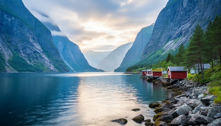
Norway boasts over 1,000 fjords along its western and northern coasts, each with its own character. While the famous Geirangerfjord and Nærøyfjord draw crowds (and UNESCO recognition), exploring quieter alternatives like Hjørundfjord or Sørfjord offers equally stunning scenery with fewer tour buses. Many travelers start their fjord adventures from Bergen fjord routes which provide easy access to both celebrated and lesser-known inlets.
What makes Norwegian fjords particularly special is their accessibility combined with pristine preservation. You can kayak through mirror-like waters in the morning, hike to cascading waterfalls by afternoon, and spot porpoises or seals along the way. These aren’t remote wilderness areas requiring expedition-level planning. They’re living landscapes where small farming communities have existed for centuries, maintaining traditions while welcoming respectful visitors who want to experience Norway’s most defining natural feature.
The Science Behind Norway’s Fjords
Why Norway Has the World’s Best Examples
Norway sits at a geological sweet spot that turned it into the world’s fjord capital. During the last ice age, the Scandinavian ice sheet, one of the planet’s largest, centered directly over the Norwegian mountains. This massive dome of ice, up to 3,000 meters thick, flowed outward under its own weight, grinding westward toward the Atlantic with relentless force for tens of thousands of years.
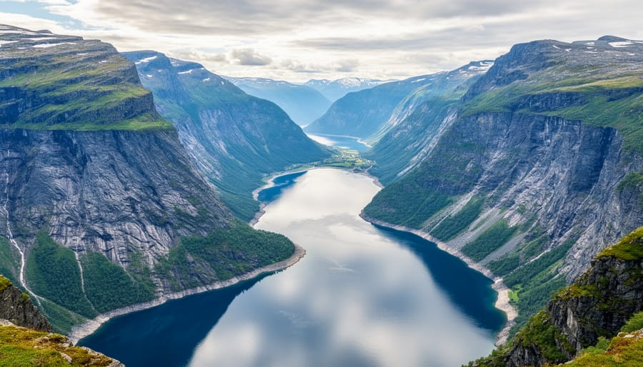
The magic happened where ice met topography. Norway’s west coast featured deep valleys already carved by ancient rivers, running perpendicular to the coastline. As glaciers surged through these channels, they excavated them far deeper than water alone could manage, scouring out basins with fjord bottoms below sea level some reaching depths exceeding 1,200 meters. When the ice melted around 10,000 years ago, the sea rushed in to fill these over-deepened valleys.
The sheer number of Norwegian fjords, over a thousand, stems from the coastline’s orientation. Mountains rise abruptly from the sea, creating perfect conditions for glaciers to flow straight from highland ice fields to the ocean. This differs markedly from other fjord regions: New Zealand’s South Island has spectacular examples but far fewer, while Chile’s coastline produces longer fjords that lack Norway’s dramatic vertical relief.
Scotland and Alaska have genuine fjords too, but Norway’s combination of depth, frequency and accessibility remains unmatched. The country essentially became a natural laboratory for fjord formation.
Key Features That Define a True Fjord
When you’re exploring Norway’s coastline, knowing what makes a true fjord helps you recognise the difference between these ancient formations and other water-filled valleys. Not every inlet or bay qualifies as a fjord, and the specific features that define them reflect their unique ice-age origins.
The most striking characteristic is that fjords have steep sides rising dramatically from the water, often with near-vertical rock walls climbing hundreds of metres above the surface. These sheer cliffs show where glaciers gouged through solid rock, creating the distinctive U-shaped valley profile rather than the V-shape carved by rivers. When you stand at water level and look up at these towering walls, you’re seeing the massive scale of ice that once filled the entire valley.
True fjords share several defining features:
- Exceptional depth relative to width, often hundreds of metres deep with steep underwater walls that mirror the cliffs above
- Direct connection to the open sea, allowing saltwater to flow in and mix with freshwater from rivers and rain
- A shallow sill or threshold near the mouth where the glacier deposited rock and sediment, creating a natural barrier
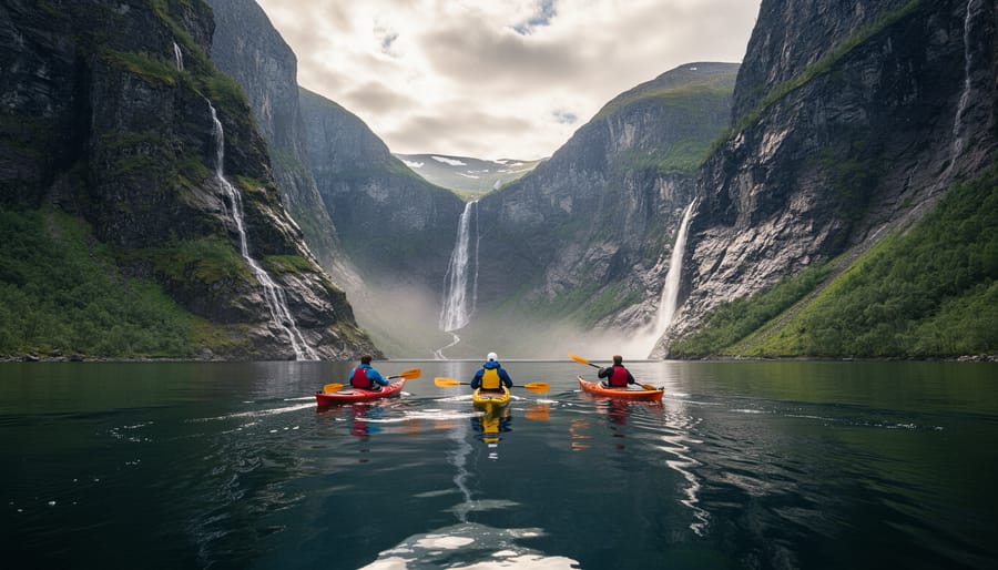
- Hanging valleys high on the cliff walls where tributary glaciers once joined the main ice flow, now often marked by spectacular waterfalls
- Layered water system with fresher, lighter water floating atop denser saltwater, creating unique conditions for marine life
These waterfalls deserve special mention because they’re visible markers of the fjord’s formation. When the massive glacier carved its deep valley, smaller side glaciers couldn’t cut as deep. After the ice melted, their valleys were left suspended high above the fjord floor, so rivers now plunge hundreds of metres straight down the rock face.
You’ll also notice that fjords extend far inland from the coast. Some stretch more than 200 kilometres from the open ocean, winding between mountains that remain snow-capped even in summer. This inland reach distinguishes fjords from simple coastal bays and reflects how far the glaciers pushed through the landscape.
The Living Ecosystem of Norwegian Fjords
Norwegian fjords aren’t just geological marvels. They’re living laboratories where two worlds collide.
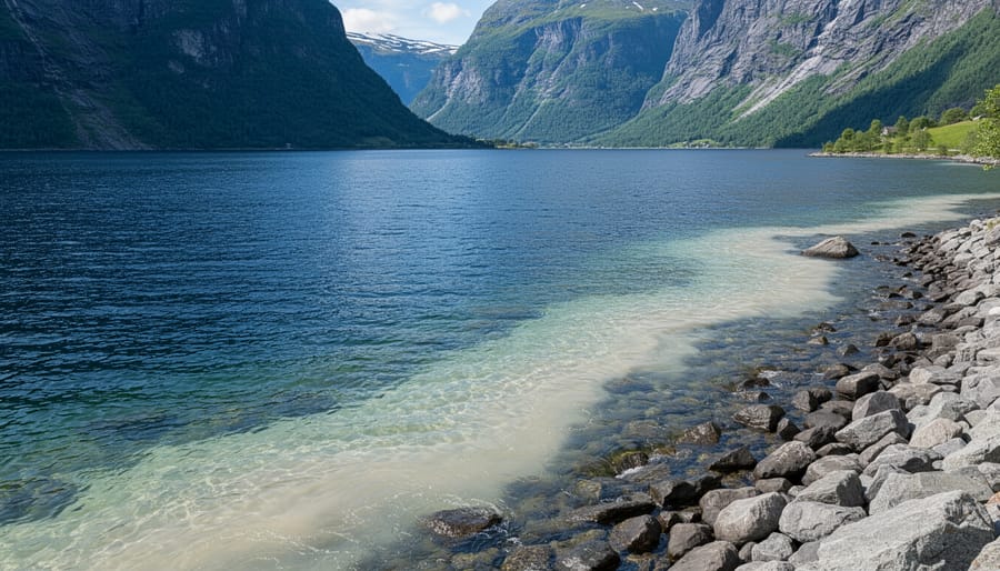
Where the saltwater from the Atlantic meets freshwater cascading down from mountains and glaciers, something remarkable happens. This mixing zone, called brackish water, creates conditions that support an extraordinary range of species. The saltwater brings in nutrients from the deep ocean, while the freshwater carries minerals from the land. Together, they form one of the most productive marine ecosystems on Earth.
Look into the dark waters and you’ll find cod, herring, and pollock sharing space with salmon making their journey between river and sea. The fjord walls plunge so deep that cold-water corals cling to the sides hundreds of meters down, creating underwater gardens that rival tropical reefs in biodiversity. Harbor seals haul out on rocky outcrops, their curious eyes tracking passing kayakers. If you’re lucky, you might spot harbor porpoises breaking the surface or even orcas hunting in the outer reaches.
Scan the clifftops and you’ll see white-tailed sea eagles, Europe’s largest birds of prey, soaring on thermal currents. These magnificent creatures nearly disappeared from Norway in the mid-20th century but have made a strong comeback, with fjord regions serving as their stronghold.
For coastal communities, fjords have always been more than scenery. They’re highways, harbors, and larders combined. Small fishing villages still dot the shorelines, their economies built on the rich marine life the fjords sustain. Aquaculture farms raise salmon and trout in the sheltered waters, though responsible operations work carefully to maintain ecological balance.
This delicate ecosystem faces pressures from climate change, pollution, and overtourism. The mixing patterns that make fjords so productive can also trap pollutants, making them vulnerable to runoff and industrial impact.
Norway’s Most Famous Fjords (And Some You Haven’t Heard Of)
Geirangerfjord and Nærøyfjord earned their UNESCO World Heritage status for good reason. These twin jewels showcase fjord geology at its most dramatic: sheer cliffs rising 1,400 meters straight from water that plunges over 500 meters deep, with waterfalls like the Seven Sisters cascading down rock faces carved during the last ice age. The narrow profile of Nærøyfjord, barely 250 meters wide at points, demonstrates how efficiently glaciers could carve through solid bedrock. Geirangerfjord’s famous farms clinging to impossible slopes tell stories of human adaptation to this extreme landscape.
But Norway has over a thousand named fjords, and some of the most geologically fascinating receive a fraction of the attention. From Bergen, the gateway to some of Norway’s most breathtaking fjords you can reach both famous and hidden gems.
| Fjord | Maximum Depth | Length | Notable Feature | Crowd Level |
|---|---|---|---|---|
| Geirangerfjord | 260m | 15km | Vertical cliffs, multiple waterfalls | Very High |
| Nærøyfjord | 500m | 17km | Narrowest profile (250m wide) | Very High |
| Aurlandsfjord | 962m | 29km | Extraordinary depth, side arm of Sognefjord | Moderate |
| Hjørundfjord | 400m | 35km | Surrounded by Sunnmøre Alps peaks | Low |
| Lysefjord | 422m | 42km | Preikestolen cliff, granite walls | Moderate-High |
Aurlandsfjord, branching off massive Sognefjord, reaches nearly a kilometer deep. That’s deeper than many ocean trenches, yet it sits surrounded by mountains. The geological forces required to gouge such a void, then the precise sea level rise needed to flood it, make this an extraordinary example of glacial power.
Hjørundfjord in the Sunnmøre region offers something Geiranger can’t: isolation. The same U-shaped valley walls and hanging waterfalls exist here, but you’ll share them with locals rather than tour buses. The Sunnmøre Alps rising directly from the fjord create a compressed landscape where alpine and marine ecosystems meet abruptly.
Lysefjord showcases different geology: light-colored granite rather than darker gneiss, creating distinct visual character. The famous Preikestolen viewpoint sits 604 meters above the water, offering perspective on the fjord’s scale that you can’t get from sea level.
Each fjord has its own geological signature, from the rock types exposed in its walls to the specific glacial history that shaped its profile. Understanding this variety means recognizing that no two fjords are identical, even when formed by the same ice age processes.
Experiencing Fjords Sustainably
The best way to protect these ancient valleys is to visit them thoughtfully. Late spring (May to early June) and early autumn (September) offer fewer crowds and softer light, though you’ll need layers. Summer brings midnight sun and warmer weather, but also peak traffic on popular routes.
Electric ferries now connect many fjord communities, running quieter and cleaner than their diesel predecessors. The ferries between Flåm and Gudvangen, and across Geirangerfjord, have gone electric in recent years. These aren’t just transport, they’re the experience itself. You’ll glide past waterfalls without engine noise drowning out the sound of cascading water. Many visitors start in Bergen where electric options for day trips from Bergen make sustainable exploration straightforward.
Kayaking puts you at water level with zero emissions. You’ll notice details invisible from ferry decks: how the water changes color where freshwater streams meet salt water, the texture of rock faces, the way sound behaves differently in these deep valleys. Guided kayak tours often employ local experts who share knowledge about geology and wildlife that you won’t find in guidebooks. Choose operators certified by organizations like Sustainable Adventure Norway or those displaying the Norwegian Ecotourism certification.
Skip helicopter tours. The noise disturbs wildlife and shatters the profound quiet that makes fjords spiritually restorative. That silence is part of what you came for.
When you visit small fjord villages, spend money there. Eat at local restaurants serving fish caught that morning. Buy provisions from village shops rather than stocking up in cities. These communities depend on tourism but deserve visitors who contribute to their economy, not just snap photos and leave.
Respect the principle of allemannsretten, the right to roam, which comes with responsibility. Pack out everything you pack in. Stay on marked trails near cliff edges. If you’re wild camping, pitch your tent at least 150 meters from buildings and move on after two nights.
The fjords have survived millennia of geological violence. What threatens them now is not ice or stone, but the cumulative impact of millions of visitors who love them. Visit with care, and they’ll remain as extraordinary for future generations as they are today.
Standing at the edge of a Norwegian fjord, you’re not just looking at a pretty view. You’re witnessing millions of years of Earth’s history written in rock and water, a place where ice age glaciers left their mark so profoundly that the landscape still bears their signature today. These aren’t static monuments but living systems where salt meets fresh water, where ecosystems thrive in the interplay between mountain and sea, and where human communities have built their lives around these dramatic waterways for millennia.
Understanding what creates a fjord transforms how you experience them. When you spot those steep walls plunging into impossibly deep water, or watch a waterfall cascade from a hanging valley hundreds of meters above, you’re seeing specific geological processes in action. You’re reading the story of ice and time carved into the Norwegian coast.
Whether you’re planning your first trip or returning to explore deeper, seeing fjords as the complex natural wonders they are enriches every moment spent among them. Our Norway fjord guide offers detailed information on visiting responsibly, choosing sustainable routes, and discovering both famous and lesser-known fjords that embody Norway’s geological heritage. These ancient valleys aren’t just backdrops for your photos. They’re Norway’s soul, shaped by ice and alive with possibility.